

Some of My Favorite Hikes
Exercising in Nature
I like a hike that challenges me, leaves me craving a beer and a burrito, and pretty much guarantees I’ll need a nap afterward.
I usually do loop hikes. Mount Desert Island was shaped by glaciers, which means most east–west trails are very steep, while north–south trails tend to follow gentler ridge lines. Since I really dislike coming down steep slopes (not great for the knees), I plan my hikes to start by going up a steep east–west trail, then follow a north–south ridge, and finally return on a carriage road or another flatter trail back to where I started.
There are exceptions, of course…
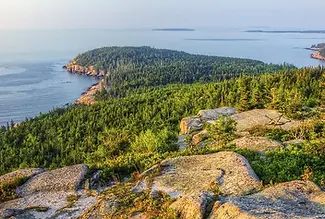
🫧 The Bubbles
Start at Jordan Pond House and walk the Jordan Pond trail to the South Bubble trail. This is a challenging hike and includes a couple of iron ladders to climb—probably not a good choice for dogs or small children.
From the top, take the connector trail over to North Bubble, then head down to a carriage road. Turn right and follow it to a connecting trail back to Jordan Pond.
🪜 Dorr Mountain from the East
The Ladder Trail is often called the world’s longest stairway—and it feels like it. It’s literally about half a mile of stairs. The Schiff Path is also very steep and includes a couple of ladder climbs.
The views at the top are wonderful. From there, take the Dorr South Ridge down and return via The Gorge back to the parking area.
🐐 Norumbega Mountain
This hike starts via the Connector Trail, near Lower Hadlock Lake. You’ll walk along the lake and then take the Norumbega Connector to the Goat Trail up.
The Goat Trail isn’t especially technical—it’s just really, really steep. From the summit, take the Norumbega Mountain Trail back down to complete the loop.
🏔️ Cadillac South Ridge
Unlike the others, this is an out-and-back hike. It’s an easy hike, but it’s a long one—about 7 miles round trip.
I love this hike because you get to cross some of the Mount Desert Island “deserts”, and of course, you get to say you climbed Cadillac Mountain.

Hiking in Acadia
There are many wonderful hikes in Acadia National Park.
The first place you'll want to visit is the park's welcome center which is located off Rt.3 to purchase a good trail map.
I recommend the "Acadia National Park Waterproof Trail Map".
Hulls Cove Visitor Center: 25 Visitor Center Rd, Bar Harbor, ME.
Bar Harbor Chamber of Commerce: 2 Cottage Street, Bar Harbor, ME.
Also, you can find some maps on the National Park Service website:
https://www.nps.gov/acad/planyourvisit/maps.htm
All the trails have wonderful views and are well marked. There are trails that range from easy to challenging.
Once I've decided on a hike, even if I bring the paper map along, I like to take a photo of the specific section on my phone. It's much easier to glance at a photo on the trail than to stop and unfold (and refold) a map. You can also download maps directly to your phone before heading out. Cell service can be spotty or unavailable in parts of Acadia, so having maps saved offline can make navigation much easier.
When you look at the map, you'll see that the island was combed by glaciers. The result is all the east-west trails are fairly short but very steep while the north-south trails are fairly easy ridges but very long.
When planning hikes, I often like to go up on an east–west trail and down on a north–south trail, then take a connecting path—often a carriage road—back to where I parked. It’s a gentler approach overall, since going up a steep trail is much easier (and kinder on your knees) than heading straight down.
The National Park Service offers an excellent website to help you choose your hikes. You’ll find detailed trail descriptions, helpful maps, and route information, (along with a gallery of photos that show what the trails look like before you head out), to make planning your adventures in Acadia and on MDI easy and enjoyable.
To help you choose a hike that fits your interests and ability level, the National Park Service has organized many of the trails by Location, Environment, and Route style:
National Park Service Acadia & Island Maps
National Park Service Carriage Road Map
AllTrails - Best Trails in Maine
AllTrails - Best Trails in Acadia
AllTrails - Acadia
Listed in the following pages are a few popular hikes to get you started.
Some of the More Popular Hikes
Easy Hikes
Coastal
Trail Trailhead: Ship Harbor
Distance: 1.5 mi roundtrip
Type: Loop
Difficulty: Easy
Elevation Gain: 65 ft
Time: 30-60 minutes
Dog Friendly: Yes
The Ship Harbor Trail is a family-friendly, figure-eight loop near Seawall Campground, known for quiet coves, spruce forest, and excellent birdwatching, including loons, eiders, herons, ospreys, and eagles. The inner loop is mostly hard-packed gravel and partially accessible, while the outer loop includes dirt, rocks, roots, and ledge with beautiful ocean views. Interpretive signs appear along the way and low tide reveals tidepools—explore carefully and never turn your back on the water.

Trailhead: Ocean Path
Distance: 4.5 miles
Type: Out and Back
Difficulty: Easy
Elevation Gain: 350 ft
Time: 2-4 hours
Dog Friendly: Yes
The Ocean Path is an easy shoreline walk from Sand Beach to Otter Point, with classic Acadia views of cliffs, pink granite, and the open ocean. Highlights include Thunder Hole, Monument Cove, and Otter Cliff, with many spots to explore the rocky shore. The trail is mostly flat with some rocky sections and short stairs—go early or near sunset to avoid crowds, and use parking areas along Park Loop Road.

Trailhead: Wonderland Trail
Distance: 1.4 miles roundtrip
Type: Loop
Difficulty: Easy
Elevation Gain: Minimal
Time: 30- 60 minutes
Dog Friendly: Yes
The Wonderland Trail is an easy, family- and pet-friendly walk to the ocean with tide pools, coastal wildlife, and views of Duck Islands and Great Cranberry Island. Mostly flat with a gravel surface, it has a short rocky section on the way to the shore and a simple loop at the end through spruce–fir forest and along the rocky coastline. Explore tide pools carefully and only as the tide goes out.

Trailhead: Bridge Street
Distance: 1.9 miles roundtrip
Type: Out and Back
Difficulty: Easy
Elevation Gain: Minimal
Time: 45- 90 minutes
Dog Friendly: Yes
The Bar Island Trail is one of the most unique and memorable walks on Mount Desert Island. At low tide, a natural gravel sandbar emerges from the ocean, allowing you to literally walk across Frenchman Bay from downtown Bar Harbor to Bar Island. The exposed land bridge is about a half-mile long and only accessible during low tide. Once across, a wide gravel road gently climbs through spruce forest to the summit of Bar Island, where you’re rewarded with sweeping views of: - Bar Harbor - The Porcupine Islands - Cadillac Mountain - Frenchman Bay

Forest and Pond Hikes
Trailhead: Jordan Pond Path
Distance: 3.4 miles
Type: Loop
Difficulty: Easy
Elevation Gain: 100 ft
Time: 1-2 hours
Dog Friendly: Yes
This scenic walk around the lake offers beautiful views of the pond and the Bubbles, with unique boardwalks and peaceful wooded sections. It can get crowded and parking fills early, but aside from a short rocky stretch and a few muddy spots, it’s an easy, enjoyable trail with sandy areas to relax by the shore.

Trailhead: Sieur de Monts
Distance: 1.8 miles
Type: Loop
Difficulty: Easy
Elevation Gain: 95
Time: 1 hour
Dog Friendly: Yes
This easy 1.8-mile loop is great for pets and young children, offering fresh coastal air, gentle woods, and occasional wildlife and wildflowers. The trail circles the Kebo Valley Golf Course and crosses a few quiet roads, passing streams, cemeteries, and connections to Jesup Path, Hemlock Road, and Kebo Brook Trail. It’s an accessible, relaxing walk with several access points and an easy route back into town.

Trailhead: Sieur de Monts
Distance: 1.5 miles
Type: Loop
Difficulty: Easy
Elevation Gain: 75
Time: 1 hour
Dog Friendly: Yes
Named for philanthropists Morris and Maria Jesup, was built in 1916 and begins near Sieur de Monts, marked by a memorial plaque. This easy loop passes through the Great Meadow Wetland, featuring long birch stands and a wide wooden boardwalk. It’s an accessible, family-friendly walk known for its peaceful scenery, fall foliage, and connections to the Hemlock Path—though it can get crowded at peak times.

Moderate Hikes
Trail Trailhead: Cadillac Mtn
Distance: 4.4 mi
Type: Out and Back
Difficulty: Moderate
Elevation Gain: 1,148
Time: 2-4 hours
Dog Friendly: Yes
Cadillac Mountain can be reached by several trails, each offering a different challenge and experience. The North Ridge Trail, (4.4 miles round trip), is the most popular—shorter, moderately easy, and great for families. The South Ridge Trail, (7 miles round trip), is longer and more gradual, with big views and a steeper scramble near the top. The West Face Trail, (0.8 miles one way), is the steepest and most strenuous, climbing nearly 1,200 feet in under a mile. The Gorge Path, (1.9 miles one way - often combined with North Ridge for a 4.8-mile loop), is a cool, narrow route between Cadillac and Dorr, while the Dorr Mountain/Nature Center Trail requires climbing Dorr first before continuing to Cadillac. Other access points include the Bubble & Jordan Ponds Path, Emery Path, and Homans Path.

Cadillac Mountain North Ridge View
Trail Trailhead: Beech Mtn.
Distance: 2.4
Type: Loop
Difficulty: Moderate
Elevation Gain: 360 ft
Time: 1- 2 hours
Dog Friendly: Yes
The Beech Mountain Loop is a moderate hike that starts in the forest, then climbs rocky slopes and granite steps to summit fire tower, one of the island’s last remaining fire towers, with views of Long Pond, Mansell Mountain, and the west side of Mount Desert Island. After enjoying the views, the route follows the South Ridge and Valley Trail back through the woods to the parking area. It’s a great sunset hike, but rocky sections can be slippery when wet.

Trail Trailhead: Gorham Mtn.
Distance: 3.5 mi
Type: Loop
Difficulty: Moderate
Elevation Gain: 567 ft
Time: 2-3 hours
Dog Friendly: Yes
The Gorham Mountain Loop is a moderate hike featuring granite ledges, ocean views, and a great overview of Acadia’s coastal scenery. From the Gorham Mountain trailhead, the route climbs gradually over open granite to viewpoints overlooking Sand Beach, Thunder Hole, and the Atlantic, with an optional spur along the more challenging Cadillac Cliffs Trail (with rungs and ladders). After reaching the summit, the loop descends to the Bowl Trail, crosses to Sand Beach, and returns via the Ocean Path past Thunder Hole back to the trailhead. The terrain is rocky with uneven footing, so good footwear is essential—especially in winter.
Trail Trailhead: Bubbles Divide
Distance: 1.5 mi
Type: Out and back with forks
Difficulty: Moderate
Elevation Gain: 500 ft
Time: 1-1.5 hours
Dog Friendly: Yes
This 1.5-mile round-trip hike quickly leads to North Bubble, South Bubble, and the famous Bubble Rock, with sweeping views of Jordan Pond and surrounding peaks. Starting from the Bubbles Divide parking lot, the trail climbs through forest and steep rocky sections to each summit, then follows blue blazes to Bubble Rock before returning on the same path. It’s a short, rewarding hike with classic Acadia scenery—use caution on exposed granite, especially when wet.

Bubble Rock - A Glacial Erratic Rock
Difficult Hikes
Trail Trailhead: Echo Lake
Distance: 2.4
Type: Loop
Difficulty: Strenuous
Elevation Gain: 488 ft
Time: 1 -2 hours
Dog Friendly: No
The Beech Cliff Ladder and Canada Cliffs Trail is a short but strenuous featuring four iron ladders, steep rock steps, and outstanding views over Echo Lake, St. Sauveur Mountain, and nearby peaks. Hiked counter-clockwise, you climb the ladders and descend the gentler Canada Cliffs Trail. The route quickly leaves the busy Echo Lake beach area behind and offers dramatic cliff-top vistas—though the ladders and heights may challenge some hikers. Dogs are allowed on leash but must be carried on the ladder section. After finishing the loop, many hikers enjoy a swim in warm Echo Lake.

Trailhead: Precipice Trail
Distance: 2.3 mi
Type: Loop
Difficulty: Hard (climbing)
Elevation Gain: 1,050 ft
Time: 2-3 hours
Dog Friendly: No
The Precipice Trail is a very strenuous loop up the sheer cliffs of Champlain Mountain, using iron rungs, ladders, and exposed ledges to climb more than 1,000 feet in under a mile. It is only for fit, sure-footed hikers with no fear of heights and should never be attempted in wet conditions. The route feels more like a non-technical climb than a hike, with boulder scrambles, narrow ledges, and long ladder sections leading to spectacular views over Frenchman Bay. Descending the Precipice is unsafe; hikers return via the North Ridge Trail and the Orange & Black Path. It’s one of Acadia’s most thrilling—but most challenging—adventures.

Trailhead: Beehive Trail
Distance: 1.4 mi roundtrip
Type: Loop
Difficulty: Hard (climbing)
Elevation Gain: 450 ft
Time: 1- 3 hours
Dog Friendly: No
The Beehive Trail is a short but demanding loop featuring steep granite stairs, exposed cliff edges, and iron rungs that require sure footing and comfort with heights. This iconic Acadia ladder trail climbs about 450 feet and rewards hikers with stunning views of Sand Beach, Thunder Hole, and the Gulf of Maine. Pets are not allowed, and good footwear is essential—especially since wet granite becomes dangerously slippery. Go early to avoid crowds and only attempt this trail if you’re prepared for exposure and challenging terrain.

Trail Trailhead: Acadia Mtn
Distance: 5.5 mi
Type: Loop
Difficulty: Hard
Elevation Gain: 1,528 ft
Time: 3-4 hours
Dog Friendly: No
Acadia Mountain Trail is a short but strenuous hike with a steep climb to a rocky summit overlooking Somes Sound, Norumbega Mountain, and Sargent Drive. Starting from Route 102, the trail ascends quickly over stone steps and ledges, then drops steeply on the far side with some scrambling required. Hikers can return the same way or make a longer 3.7-mile loop with St. Sauveur Mountain or a gentler descent via the Man O’ War Brook Trail. Parking and restrooms are across the road—use caution when crossing.

Acadia Mountain Trail
Hike Historic Trails
There are seven memorial paths: Emery Path, Homans Path, Schiff Path, Beachcroft Path, Kurt Diederich's Climb, Jesup Path, and Kane Path.
Across the park, there are several other paths constructed during 1924 to 1930: A. Murray Young Path, Gorge Path, Canon Brook Path, Giant Slide Trail, Gorham Mountain Trail, and Cadillac Cliffs Trail. Notable trails constructed by the CCC are Ocean Path and Perpendicular Trail. Today, hikers can follow the footsteps of early settlers, American Indians, and outdoors enthusiasts of another era. Acadia’s historic trails remain just as challenging and rewarding, offering breathtaking scenery and a timeless connection to the landscape that continues to inspire awe.

Distance: .5 miles one way
Terrain: A steady forest climb with sections of rocky trail and granite steps, becoming more open and rocky near the summit of Dorr Mountain.
A scenic, steep hiking trail in Acadia National Park known for its historic, high-quality granite stairwork and impressive views of the Great Meadow and Frenchman Bay. It is a popular route to the summit of Dorr Mountain. As you climb, the trail opens onto broad ledges offering beautiful views of the surrounding forests, meadows, Bar Harbor, and the Porcupine Islands. The path features intricate stonework, narrow passages, and exposed ledges with drop-offs that may be intimidating to those afraid of heights.

Distance: .3 miles one way
Terrain: A steep and rugged granite staircase with iron rungs and exposed rock ledges leading directly up the south face of Dorr Mountain.
A short, steep, moderately challenging memorial hiking trail in Acadia National Park that features intricate granite stonework and steps. It connects to other trails, notably Emery Path and Jesup Path, and can be used to reach the summit of Dorr Mountain. It offers views of the Great Meadow, the Porcupine Islands, and Frenchman Bay. The trail is characterized by impressive, engineered stonework, including granite steps, narrow passages between rock slabs, and a forest environment.

Distance: Varies
Terrain: A quiet woodland trail with rocky footing and moderate grades, gradually climbing through forest toward the Dorr Mountain area.
A popular, strenuous hiking trail in Acadia National Park that runs along the east face of Dorr Mountain and connects several other trails, including the Ladder Trail, Emery Path, Homans Path, and Kurt Diederichs Climb, to the mountain's summit. The path is known for its extensive granite steps and exposed ledges offering views of Frenchman Bay and The Tarn. It is part of a series of historic "memorial paths" constructed in the early 20th century.

Distance: 2 miles round trip
Terrain: A historic stone stair trail built with long sections of granite steps and open ledges, offering sweeping views while ascending Champlain Mountain.
A scenic and historic 2-mile (round trip) trail in Acadia National Park that leads to the summit of Champlain Mountain, offering panoramic views of Frenchman Bay and the surrounding islands. The trail is generally considered challenging, with sections of granite stairs and rocky scrambles. The trail goes around Huguenot Head and provides excellent views of The Tarn and Dorr Mountain. The summit of Champlain Mountain (1,058 ft) offers sweeping views of the Maine coast, Frenchman Bay, and the outlying islands.

Distance: .4 miles one way
Terrain: A very steep granite slab route with iron rungs and exposed scrambling, climbing dramatically up the cliffs of Champlain Mountain.
A short, steep, and scenic hiking trail in Acadia National Park, Maine, known for its extensive granite steps and a memorial at the trailhead. It connects several other paths at the base of Dorr Mountain. The trail starts near the Sieur de Monts Nature Center and the Tarn, a marshy pond. Hikers can begin on the Jesup Path briefly before turning onto Kurt Diederichs Climb. The climb is a relentless, steep ascent on granite steps. As you climb, you get views of the Tarn, Huguenot Head, and Champlain Mountain. The path ends at a junction with the Schiff Path and Emery Path, which can be followed to reach the summit of Dorr Mountain.

Distance: 1.5 miles round trip
Terrain: An easy boardwalk trail crossing wetlands and spruce forest, mostly flat and ideal for a relaxed walk.
An easy, family-friendly trail in Acadia National Park, famous for its scenic boardwalk through a white birch forest and marshy wetland. The trailhead is located at the Sieur de Monts Nature Center, which also provides access to the Wild Gardens of Acadia and the Abbe Museum. The trail features picturesque views of the Great Meadow and surrounding mountains like Dorr Mountain, opportunities for birdwatching, and a unique section that winds through a boggy white birch forest.

Distance: : 0.8 miles to the Canon Brook Trail junction
Terrain: A moderately steep forest trail with rocky footing and occasional granite ledges, climbing toward Champlain Mountain.
An easy, historic trail, known for its large stepping stones along the edge of The Tarn pond, offering views of flora, fauna, and surrounding mountains, connecting to other popular trails like Dorr Mountain Ladder Trail and Jesup Path for longer hikes. It's a relatively flat, wooded path ideal for families, though some boulder-hopping sections require careful footing, and it provides access to the Wild Gardens of Acadia.

The 9 Great Ponds in Acadia
Lower Hadlock Pond Loop
Distance: 1.8 - 2 Miles
A tranquil forest loop with reflective pond views and rustic boardwalk bridges. Though relatively short and mostly level, roots, uneven terrain, and occasional boggy sections may feel moderately challenging for some hikers. A quiet, less-crowded alternative to busier trails. The entire trail remains shaded beneath a canopy of trees, making it especially pleasant on warm days or during light rain.

Photo Credit: National Park Service
Distance: 4.1 (Upper and Lower Combined
A scenic and quieter 4.1-mile loop featuring peaceful pond views, shaded forest paths, and charming wooden footbridges. While elevation gain is modest, roots, rocky sections, and occasional soft footing give it a moderate rating. The trail connects to carriage roads leading to 40-foot Hadlock Falls.

Distance: 5.9 Miles
This scenic carriage road loop circles Eagle Lake with mostly level terrain on the east and north sides and a gradual climb near intersection 8. Rough patches and minor elevation changes give it an easy–moderate rating. Connects to the Around the Mountain and Jordan Pond Loops.

Distance: 4.7 Miles
A peaceful carriage road loop winding through forest and around Witch Hole Pond. This gentle route has very little elevation change, making it ideal for a relaxed walk or easy bike ride. Along the way, it passes several small ponds and a charming bridge featuring a small cascading waterfall. A lovely, quiet option for those seeking calm scenery and smooth riding or walking conditions.

Distance: 1.8 - 2 Miles
A flat, scenic carriage road following Bubble Pond beneath Pemetic Mountain and the Bubbles. Calm water reflections and surrounding rounded peaks make this a beautiful, peaceful walk or easy bike ride for all ages. A historic stone bridge sits near the pond. Parking Note: The small lot is closed to private vehicles during Island Explorer Shuttle season (late June–early October). Shuttle access is typically required in peak summer months.

Distance: 6.1 Miles
A scenic, traffic-free gravel carriage road passing the 38-acre, bird-rich wetlands of Aunt Betty Pond. Surrounded by mixed forest, the area is popular for birdwatching, biking, and hiking, and is often included in the Around the Mountain carriage road routes.

Distance: 3.3 Miles
An easy, family-friendly trail in Acadia National Park, famous for its scenic boardwalk through a white birch forest and marshy wetland. The trailhead is located at the Sieur de Monts Nature Center, which also provides access to the Wild Gardens of Acadia and the Abbe Museum. The trail features picturesque views of the Great Meadow and surrounding mountains like Dorr Mountain, opportunities for birdwatching, and a unique section that winds through a boggy white birch forest.

Distance: 0.1 Miles to Beach
Often cited as one of the warmest swimming spots on Mount Desert Island, Lake Wood is a hidden gem that feels tucked away despite being close to Hulls Cove Visitor Center. This secluded pond features a small beach, clear jade-colored water, and a sandy bottom with gentle entry — ideal for cooling off on a summer day. A short trail leads to a deeper section popular for cliff jumping. For a quieter experience, follow one of the narrow paths along the shoreline to find a more private spot away from the main parking area.

Distance: 3.3 Miles
Round Pond is a quiet 38-acre freshwater pond along Pretty Marsh Road on the western side of Mount Desert Island. The western shoreline borders Acadia National Park, while the eastern side is privately owned. Stocked with fish and popular with anglers, it can only be accessed by a short rough path from Route 102—there’s no boat launch and very limited roadside parking. A peaceful, off-the-beaten-path spot for paddling or fishing.

Maine's First Lake
Several trails to choose from to access
Tucked between the summits of Penobscot and Sargent Mountains at about 1,200 feet, Sargent Mountain Pond is a pristine, high-elevation lake in Acadia National Park. Believed to be one of the first lakes to form in Maine after the last Ice Age, it is naturally acidic and fishless, creating a rare and fragile ecosystem. Reached by strenuous, rocky trails (typically 4+ miles round trip), this secluded pond rewards hikers with cold, crystal-clear water and a peaceful mountain setting — plan ahead and avoid starting your hike late in the day.

🏔 The 26 Mountain Summits of Mount Desert Island 🏔
There are 26 mountain summits that can be hiked in Acadia National Park on Mount Desert Island.
With so many trailheads, route options, and online recommendations, choosing where to start can feel overwhelming. This guide is designed to simplify the process and help you quickly determine which mountain — and which trail — is right for you.
Below are the 26 summits listed from highest to lowest elevation:
(Trail info and Links to AllTrails)
Cadillac Mountain – 1,530 ft
The highest point in Acadia and the only summit accessible by auto road. Famous for sunrise views and sweeping 360° panoramas.
Sargent Mountain – 1,373 ft
Second highest peak with wide-open granite summit and fewer crowds than Cadillac.
🧗
3.3 mi OB
3-4 hrs
A steep, challenging, and scenic route often combined with a Penobscot Mountain hike.
Dorr Mountain – 1,270 ft
Granite dome east of Cadillac with several classic ascents.
🔴
3.3 mi RT
2–3 hrs
Links with the Gorge Path and Ladder Trail to reach the summit, often featuring rocky, exposed, and sometimes vertical terrain.
🟡
.5 mi
2-3 hrs
Challenging, steep trail featuring extensive stone steps and granite, often combined with the Schiff Path or Gorge Path
🔴
3.2 mi Loop
2-2.5 hrs
Often used as the descending leg of the SR Loop, as it offers a more gradual alternative to the steep, ladder-intensive east face.
Pemetic Mountain – 1,248 ft
Towering between Jordan Pond and Bubble Pond, offering iconic postcard views.
🔴
4 mi Loop
2–3 hrs
Flat forested lake side trail, steep granite ledges and rocky trails, granite ridgelines, rooted forest trails
🟡
3.4 mi RT
2 -2.5 hrs
Enjoy simple dirt trails and granite ridgeline throughout this hike.
Penobscot Mountain – 1,194 ft
Known for its dramatic granite and ridge traverses.
🔴
2.9 mi RT
2–3 hrs
Rocky slabs with very little shade and a steady incline to the top.
Bernard Mountain – 1,071 ft
The highest peak on the Quiet Side. Long ridgelines, peaceful forests, and far fewer crowds than the eastern mountains.
2 - 2.5 hrs
Champlain Mountain – 1,058 ft
One of the most dramatic peaks in Acadia, towering above Sand Beach.
Gilmore Peak – 1,036 ft
Often combined with Bald and Parkman in a rewarding ridge hike.
🔴
3 mi RT
2-2.5 hrs
This hike ascends the steep Maple Spring Trail before summiting Gilmore Peak, Parkman Mountain, and Bald Peak.
Bald Peak – 974 ft
Open granite summit with expansive western views.
Mansell Mountain – 949 ft
Known for its dramatic cliffs and adventurous terrain.
🔴
2.3 mi RT
1.5 - 2 hrs
Strenuous; features steep, sustained, staircase-like climbing.
🔴
2.5 mi
1.5 - 2 hrs
It is typically hiked as part of a loop with the Perpendicular Trail.
Cedar Swamp Mountain – 942 ft
A quieter summit in the “middle peaks” region.
Parkman Mountain – 941 ft
Granite summit often paired with Bald and Gilmore.
North Bubble – 872 ft
Iconic view over Jordan Pond — one of Acadia’s most photographed spots.
Norumbega Mountain – 852 ft
Overlooks Somes Sound with fewer hikers.
Beech Mountain – 839 ft
Fire tower summit on the Quiet Side.
🟡
1.2 mi RT
1-1.2 hrs
Forested path, rocky trails, granite stairs and slopes, wooden steps
South Bubble – 766 ft
Home of the famous Bubble Rock, a glacial erratic perched dramatically above Jordan Pond.
🔴
3.6 mi Loop
1.5-2 hrs
Rises sharply to the summit, requiring navigation through a narrow rock crevice and potential exposure
Huguenot Head – 731 ft
A companion summit to Champlain Mountain, offering dramatic views over Sand Beach and the Atlantic.
Huguenot Head
🟡
2.4 mi RT
2-3 hrs
Choose from 4 different routes.
The Triad – 698 ft
Three small connected high points between Pemetic and Day Mountain.
🟡
2.7 mi RT
1-1.5 hrs
Offering a quiet, forested alternative to nearby popular trails, with scenic views from the top.
Acadia Mountain – 681 ft
A favorite for sunset views over Somes Sound.
St. Sauveur Mountain – 679 ft
Often paired with Acadia.
🟡
3.5-4 mi RT
2-3 hrs
Typically part of a loop rather than a solo summit hike.
Conners Nubble – 588 ft
Overlooks Eagle Lake with light boulder scrambling.
🟡
3.5 mi RT
4 - 5 hrs
The trails feature a variety of terrain, including forested paths, some rocky sections.
Day Mountain – 580 ft
The only summit accessible via carriage road; gentle and family-friendly.
Gorham Mountain – 525 ft
🟡
3.1 mi Loop
2-3 hrs
Moderate; features rocky terrain and uneven granite surfaces.
The Beehive – 520 ft
Short but thrilling iron rung climb overlooking Sand Beach.
Bowl Trail Descent
🟡
1.6-1.9 mi RT
1-1.5 hrs
Easier wooded return option.
Kebo Mountain – 407 ft
A quieter extension of Dorr Mountain, less traveled and mostly forested.
Flying Mountain – 284 ft
The shortest named summit on MDI with spectacular views over Somes Sound.
🟡
1.5 mi RT
1-1.5 hrs
Log and gravel steps. Becoming more rugged, traversing rocks and roots. exposed ledges, rocky granite and stone steps.

The 6 Summit Hike
The “Six Summits” is a challenging mountain hike in Acadia National Park that links six peaks along a rugged ridgeline, typically covering about 6.7–7 miles and taking 6–10 hours to complete. One popular route includes Bald Peak, Parkman Mountain, Gilmore Mountain, Sargent Mountain, Penobscot Mountain, and Cedar Swamp Mountain, offering sweeping views of Somes Sound, surrounding lakes, and Mount Desert Island’s dramatic landscape. The hike is considered strenuous, with steep scrambles and significant elevation gain, and is usually accessed from trails near Hadlock Brook and Upper Hadlock Pond.
Several versions of the “Six Summits” hike exist in Acadia National Park, each linking six mountain peaks along scenic ridgelines on Mount Desert Island. The exact peaks vary depending on the route chosen.
Western Ridge Six Summits (Hadlock Brook Route)
A challenging route that typically includes:
Bald Peak → Parkman Mountain → Gilmore Peak → Sargent Mountain → Penobscot Mountain → Cedar Swamp Mountain
This route is often accessed from Hadlock Brook / Upper Hadlock Pond and features rugged ridgelines with sweeping views of Somes Sound and the western side of Mount Desert Island.
Central Ridge Six Summits
Another popular variation connects peaks in the central part of the island:
Penobscot Mountain → Sargent Mountain → South Bubble → North Bubble → Pemetic Mountain → The Triad
This version links several well-known Acadia peaks and provides excellent views of Jordan Pond, Eagle Lake, and the surrounding mountains.
Cadillac Ridge Variation
Some hikers create their own six-peak traverse along the Cadillac ridgeline, often including:
Cadillac Mountain → Dorr Mountain → Pemetic Mountain → Penobscot Mountain → Sargent Mountain → Gilmore Peak
This route combines several of Acadia’s highest mountains and offers dramatic granite ridge walking and panoramic ocean views.

Waterfalls in Acadia
Acadia National Park has several small but beautiful waterfalls and cascades, most of which flow strongest in spring during snowmelt or after heavy rain. Many are located near hiking trails and historic carriage road bridges in the central and eastern areas of Mount Desert Island.
Visit Friends of Acadia for some Beautiful images of these waterfalls.
Notable waterfalls and cascades include:
Hadlock Falls – Approximately 40 feet total cascade. One of the park’s most photographed waterfalls, flowing beneath a striking stone carriage road bridge along Hadlock Brook.
Chasm Brook Falls – About 20–25 feet. A scenic cascade near the Chasm Brook Carriage Road bridge surrounded by mossy rock walls.
Little No Name Cascade – Roughly 15–20 feet. A narrow cascade along the Amphitheatre Trail where water funnels through a granite constriction.
Man O’War Falls – Approximately 15–20 feet. A rare coastal waterfall on the Acadia Mountain Trail that drops directly into the ocean.
Canon Brook Cascade – About 30–40 feet of stepped cascades along the Canon Brook Trail, sometimes visible from Route 3 during high water.
Amphitheatre Cascade – Around 10–15 feet. A picturesque cascade beneath the Amphitheatre Bridge on the carriage road system.
Duck Brook Waterfall – Small cascade of roughly 10–15 feet, located near the Duck Brook carriage road area north of Bar Harbor.
Deer Brook Falls – Approximately 10–15 feet near Deer Brook Bridge at the north end of Jordan Pond.
Tip: Many of these waterfalls slow to a trickle or dry up by late summer, so spring and rainy days provide the best viewing conditions.
Carriage Roads and Bridges
The links provided here direct you to the National Park Service website, where you’ll find detailed information for each carriage road loop. Each page includes a road description, interactive map, elevation profile graph, and estimated biking time. You’ll also find a list of bridges and their locations along the route, along with links to the history of each bridge.
In addition, the site features photo galleries of the carriage roads, historic stone bridges, and key intersections along each loop — making it easy to preview your adventure before you head out.
The 8 Named Carraige Road Loops:
Amphitheater Loop - 4.4 miles
A quieter interior loop featuring gentle grades, wooded stretches, and beautifully crafted stone bridges. It connects easily with other carriage roads and feels peaceful compared to the more popular lake routes.
Around the Mountain Loop - 11.3 miles
A longer, more remote-feeling loop that circles the western side of Sargent Mountain. Expect rolling hills, forest scenery, and fewer crowds — ideal for those wanting a more immersive ride or walk.
A moderate loop with steady climbs and rewarding views near Day Mountain. It’s a nice option if you want some elevation without tackling a steep summit trail.
A wide, beginner-friendly loop along the east side of Eagle Lake. Beautiful water views and iconic stone bridges make this a favorite for walking and biking.
A wooded loop with moderate rolling hills and charming stone bridges. Often quieter than Eagle Lake or Jordan Pond, making it great for a peaceful outing.
One of the most scenic and popular loops, offering classic views of Jordan Pond and the North and South Bubbles. Mostly gentle terrain with stunning shoreline stretches.
A scenic route connecting Eagle Lake, Bubble Pond, and Jordan Pond. This loop offers varied landscapes, smooth gravel roads, and some of the most classic carriage road scenery.
Witch Hole Pond Loop - 4.7 miles
Located near the Hulls Cove Visitor Center, this gentle loop winds through forest and past small ponds and open fields. A great choice for families and first-time visitors.

My Favorite Bike Rides
Riding the carriage roads used to be all I did when I stayed at Baycliff when I was younger.
I rode those carriage roads for 30 years - I probably had one of the first mountain bikes
of the 80s.
IMHO - it’s one of the best ways to see Acadia.
I HIGHLY recommend renting bikes and riding the carriage roads.
These go through some of the best parts of the park.
The roads have amazing historic stone bridges – each uniquely designed – some with beautiful vistas.
The Acadia National Park trail map will show the carriage roads - there are also carriage road specific maps.
I've always used Bar Harbor Bicycle Shop:
Bar Harbor Bicycle Shop - 141 Cottage St,
Bar Harbor Bike Carriage Road Map
National Park Service Carriage Road Map
National Park Service Acadia & Island Maps
It's possible to ride from the shop to one of the carriage roads - though it's a steep climb.
Paradise Hill / Witch Hole Pond:
This is a good one to start with - kind of
Parking is easy at the welcome center.
The start of the trail is in the opposite corner from where you enter the parking lot.
The problem is that you have a very steep climb to get to the carriage road from the parking lot - you may want to walk your bike.
Once on the road - this is one of the nicest easy rides – I recommend riding counter-clockwise.
The Paradise Hill / Witch Hole Pond Trail follows a peaceful section of Acadia’s carriage roads, winding through quiet woods and around Witch Hole Pond. Along the way you’ll see still water reflecting pines and spruce, beaver lodges, and marshy areas filled with birds and wildlife. On an early morning or evening trip you may spot beavers hard at work or even at play. The trail offers gentle slopes and classic stone bridges. It’s a calm, scenic loop perfect for walking, biking or enjoying a quieter side of the park.

Aunt Betty Pond
More challenging than Paradise Hill.
Park at Eagle Lake – Best ridden counter clockwise.
This is a quiet carriage-road loop that passes through woods and wetlands, circling near Aunt Betty Pond. Along the way, you’ll see marsh grasses, birdlife and peaceful views of the pond’s still water.
The Seven Sisters Bridges is a “fun” climb – I don’t recommend going down the Seven Sisters as it’s full of sharp turns – you’ll be on the breaks the whole time.
Turn left at Post “8” to go back via Eagle Lake.

Day Mountain:
I’ll call this a plus-intermediate ride.
Park at Jordan Pond.
If you want to say you’ve climbed a mountain on a bicycle - take the trail up Day Mountain - it IS a mountain…
Just remember that once you’re down - you’ll still have to ride back to Jordan Pond.
Day Mountain is a LONG steady climb with beautiful views of the surrounding forest and coastline. Near the summit, you’ll enjoy sweeping vistas of the ocean and outer islands-especially lovely in the morning light – and a welcome breeze!


Biking on Mount Desert Island & Acadia National Park
Acadia National Park is famous for its 59 miles of historic carriage roads, originally built by John D. Rockefeller Jr. These crushed-stone roads wind through forests, around lakes and ponds, and across beautifully crafted stone bridges, offering a safe, car-free biking experience through some of the park’s most scenic landscapes. Routes range from easy, relatively flat rides to more challenging climbs, rewarding riders with sweeping views of mountains, lakes, coastline, and Frenchman Bay.
Bikes are not allowed on most hiking trails, but the carriage roads provide a peaceful and scenic network for cyclists of all levels. Many riders also enjoy exploring Mount Desert Island’s quiet coastal roads and village routes, which connect Bar Harbor, Northeast Harbor, Southwest Harbor, and other harbor communities with beautiful ocean views.
Early morning or late afternoon rides are especially enjoyable, when the light is softer, the roads are quieter, and wildlife sightings are common along the way.
National Park Service Biking Info.
Popular Bike Rides in Acadia
Eagle Lake Loop
Distance: ~6 miles
Start: Eagle Lake Carriage Road entrance near Parkman Mountain Parking Area (Route 233) or Hulls Cove Visitor Center.
One of the most popular carriage road rides, this loop circles beautiful Eagle Lake with frequent lake views and gentle rolling terrain. It’s a great ride for beginners and families.
Jordan Pond Loop
Distance: ~5 miles
Start: Jordan Pond House Carriage Road entrance or Bubble Pond Parking Area.
This scenic loop passes Jordan Pond and the famous Bubbles Mountains. The ride features moderate hills and beautiful views of the pond and surrounding mountains.
Around Mountain Loop
Distance: ~10.5 miles
Start: Jordan Pond House or Brown Mountain Gate (Northeast Harbor).
A favorite longer ride that circles Pemetic, Penobscot, and Sargent Mountains. Riders enjoy forest scenery, quiet ponds, and several impressive stone bridges.
Amphitheater Loop
Distance: ~3.3 miles
Start: Parkman Mountain Parking Area (Route 233).
A short but very scenic ride that includes the Amphitheater Bridge and passes near Little Harbor Brook. This loop is perfect if you're looking for a shorter ride with classic Acadia scenery.
Witch Hole Pond Loop
Distance: ~3.9 miles
Start: Hulls Cove Visitor Center Carriage Road entrance.
One of the best rides for beginners. The terrain is mostly gentle and passes through forest and around a small pond.
Day Mountain Loop
Distance: ~4.6 miles
Start: Bubble Pond Carriage Road entrance or Jordan Pond House.
A quiet and scenic ride that climbs gently through forest before offering nice views of Somes Sound and the mountains. It connects easily with other carriage road routes.
Hadlock Loop
Distance: ~9.7 miles
Start: Hadlock Pond Parking Area (Route 3) or Brown Mountain Gate in Northeast Harbor.
This loop travels along Hadlock Brook and past Hadlock Falls, one of Acadia’s most picturesque waterfalls. The ride also crosses several historic stone bridges.
Eagle Lake – Around Mountain Loop
Distance: ~12 miles
Start: Parkman Mountain Parking Area (Route 233) or Hulls Cove Visitor Center
This is one of the most popular longer rides in Acadia. The route circles Eagle Lake, then continues onto the Around Mountain carriage road, passing between Pemetic, Penobscot, and Sargent Mountains. Riders cross several beautiful stone bridges and enjoy views of Bubble Pond and mountain ridges along the way.
Jordan Pond – Bubble Pond Loop
Distance: ~10 miles
Start: Jordan Pond House or Bubble Pond Parking Area
This scenic ride combines the Jordan Pond loop, Bubble Pond, and sections of the Around Mountain road. Highlights include views of the Bubbles Mountains, Pemetic Mountain, and the clear waters of Jordan Pond. It’s one of the most picturesque carriage road rides in the park.
Eagle Lake – Witch Hole – Paradise Hill Loop
Distance: ~11 miles
Start: Hulls Cove Visitor Center
A great ride for those starting near Bar Harbor. The loop travels around Witch Hole Pond, climbs Paradise Hill, and then circles Eagle Lake. Riders enjoy forest scenery, lake views, and several historic stone carriage road bridges.
Quiet Coastal Roads & Village Bike Routes on MDI
In addition to Acadia’s carriage roads, Mount Desert Island has many scenic coastal and village roads that are popular with cyclists. These routes follow the shoreline, connect harbor towns, and often have lighter traffic than the main Park Loop Road. Many riders combine these roads with carriage road entrances in Seal Harbor, Northeast Harbor, and Hulls Cove.
Bar Harbor to Sand Beach (Park Loop Ride)
Distance: ~12 miles round trip
Start in downtown Bar Harbor and ride south along Park Loop Road. The route follows the coast past Otter Cliff, Thunder Hole, and Sand Beach, with constant ocean views. This is one of the most scenic rides in Acadia, though traffic can be heavier in midday—early morning rides are best.
Northeast Harbor to Southwest Harbor (Somes Sound Ride)
Distance: ~7 miles one way
Start in Northeast Harbor and ride west on Route 102 along the edge of Somes Sound. The road winds between forested hills and the fjord-like waterway before arriving in Southwest Harbor, a charming working harbor village.
Southwest Harbor to Seawall
Distance: ~8–10 miles round trip
From Southwest Harbor, take Route 102A south toward Bass Harbor. The road follows the rugged western coastline and leads to Seawall Picnic Area, where waves crash against long granite ledges.
Seal Harbor to Jordan Pond
Distance: ~4 miles one way
Begin in Seal Harbor village and ride north on Route 3. This scenic climb leads directly to Jordan Pond House and the carriage road network, making it a great connection between coastal riding and the park’s bike paths.
Northeast Harbor to Pretty Marsh
Distance: ~10–12 miles round trip
Start in Northeast Harbor and ride west on Route 102, then turn onto Pretty Marsh Road. This quiet road leads to a peaceful shoreline area with views across Blue Hill Bay.
Hulls Cove to Bar Harbor Village Loop
Distance: ~6 miles
From the Hulls Cove Visitor Center, ride along Route 3 toward Bar Harbor and return via village streets and the Shore Path area. This short ride offers views of Frenchman Bay and the Porcupine Islands.

Bike Rentals
Bar Harbor-
Bar Harbor Bicycle Shop
Address: 141 Cottage St, Bar Harbor, ME
One of the closest bike shops to Acadia’s carriage roads. Rents hybrid bikes, road bikes, kids’ bikes, trailers, and accessories for riding the park’s gravel carriage roads or around town.
Acadia Bike Rentals
Address: 48 Cottage St, Bar Harbor, ME
Offers a large fleet of hybrid bikes, e-bikes, children’s bikes, tag-along bikes, and trailers, making it a popular option for families exploring Acadia.
Acadia Outfitters Bike & E-Bike Rentals
Address: 106 Cottage St, Bar Harbor, ME
Located in downtown Bar Harbor, this shop rents electric bikes and traditional bikes designed for riding Acadia’s carriage roads.
Acadia Fat Tire E-Bike
Address: 39 Cottage St, Bar Harbor, ME
Specializes in fat-tire electric bikes designed for stability and comfort on Acadia’s gravel carriage roads.
Pedego Electric Bikes Bar Harbor
Address: 67 Main St, Bar Harbor, ME
A specialty shop offering high-quality electric bike rentals and sales, ideal for exploring Acadia’s carriage roads with pedal-assist power.
Acadia Stand Up Paddle & E-Bike
Address: 113 Main St, Bar Harbor, ME
Offers electric bike rentals and stand-up paddleboards, making it easy to explore both Acadia’s carriage roads and nearby coastal waters.
Acadia-
Acadia Ebike Adventure
Location: 1 Dewey Street, Bar Harbor - Near Hulls Cove Visitor Center (inside Acadia)
Specializes in electric bike rentals and guided e-bike tours designed specifically for exploring Acadia’s carriage roads.
Northeast Harbor-
Island Bike Rental
Address: 102 Main St, Northeast Harbor, ME
Located near the Brown Mountain carriage road entrance, renting traditional bikes, cruisers, e-bikes, kids’ bikes, and trailers.
Southwest Harbor-
Island Time E-Bike Rentals
Address: 16 Village Green Way, Southwest Harbor, ME
Offers electric bike rentals and guided rides around the quieter western side of Mount Desert Island and Acadia.
Southwest Cycle
Address: 10 Clark Point Rd, Southwest Harbor, ME
A long-standing full-service bike shop offering bike rentals, sales, and repairs, with hybrid and road bikes for exploring the quieter west side of the island.
Winter Harbor-
Sea Schoodic Kayak & Bike
Address: 54 Frazier Point Rd, Winter Harbor, ME
Located on the Schoodic Peninsula, renting bikes and kayaks for exploring the quieter section of Acadia National Park.
Delivery Service around Mount Desert Island-
Acadia Royal Rides
Location: Delivery service around Mount Desert Island
Provides electric bike rentals with delivery and pickup, including helmets, locks, and maps for exploring Acadia and nearby coastal routes.
Adaptive Bike Rides
MDI Wheelers is a volunteer nonprofit organization that provides free adaptive bike rides on Acadia National Park’s carriage roads for people who are unable to ride a bicycle on their own. Using special electric-assist tricycles, trained volunteers pedal riders through scenic areas around Eagle Lake and other carriage road routes, making the beauty of Acadia accessible to seniors and individuals with disabilities.