Things to Do

Some of My Favorite Hikes
Exercising in Nature
I like a hike that challenges me, leaves me craving a beer and a burrito, and pretty much guarantees I’ll need a nap afterward.
I usually do loop hikes. Mount Desert Island was shaped by glaciers, which means most east–west trails are very steep, while north–south trails tend to follow gentler ridge lines. Since I really dislike coming down steep slopes (not great for the knees), I plan my hikes to start by going up a steep east–west trail, then follow a north–south ridge, and finally return on a carriage road or another flatter trail back to where I started.
There are exceptions, of course…
🫧 The Bubbles
Start at Jordan Pond House and walk the Jordan Pond trail to the South Bubble trail. This is a challenging hike and includes a couple of iron ladders to climb—probably not a good choice for dogs or small children.
From the top, take the connector trail over to North Bubble, then head down to a carriage road. Turn right and follow it to a connecting trail back to Jordan Pond.
🪜 Dorr Mountain from the East
The Ladder Trail is often called the world’s longest stairway—and it feels like it. It’s literally about half a mile of stairs. The Schiff Path is also very steep and includes a couple of ladder climbs.
The views at the top are wonderful. From there, take the Dorr South Ridge down and return via The Gorge back to the parking area.
🐐 Norumbega Mountain
This hike starts via the Connector Trail, near Lower Hadlock Lake. You’ll walk along the lake and then take the Norumbega Connector to the Goat Trail up.
The Goat Trail isn’t especially technical—it’s just really, really steep. From the summit, take the Norumbega Mountain Trail back down to complete the loop.
🏔️ Cadillac South Ridge
Unlike the others, this is an out-and-back hike. It’s an easy hike, but it’s a long one—about 7 miles round trip.
I love this hike because you get to cross some of the Mount Desert Island “deserts”, and of course, you get to say you climbed Cadillac Mountain.

Hiking in Acadia
There are many wonderful hikes in Acadia National Park.
The first place you'll want to visit is the park's welcome center which is located off Rt.3 to purchase a good trail map. I recommend the "Acadia National Park Waterproof Trail Map".
Hulls Cove Visitor Center: 25 Visitor Center Rd, Bar Harbor, ME.
Bar Harbor Chamber of Commerce: 2 Cottage Street, Bar Harbor, ME.
Also, you can find some maps on the National Park Service website:
https://www.nps.gov/acad/planyourvisit/maps.htm
All the trails have wonderful views and are well marked. There are trails that range from easy to challenging.
Once I’ve decided on a hike, even if I bring the paper map along, I like to take a photo of the specific section on my phone. It’s much easier to glance at a photo on the trail than to stop and unfold (and refold) a map.
When you look at the map, you'll see that the island was combed by glaciers. The result is all the east-west trails are fairly short but very steep while the north-south trails are fairly easy ridges but very long.
When planning hikes, I often like to go up on an east–west trail and down on a north–south trail, then take a connecting path—often a carriage road—back to where I parked. It’s a gentler approach overall, since going up a steep trail is much easier (and kinder on your knees) than heading straight down.
The National Park Service offers an excellent website to help you choose your hikes. You’ll find detailed trail descriptions, helpful maps, and route information, (along with a gallery of photos that show what the trails look like before you head out), to make planning your adventures in Acadia and on MDI easy and enjoyable.
The National Park Service hikes are broken down by location, environment and route type:
Listed in the following pages are a few popular hikes to get you started.
Happy Hiking
Some of the More Popular Hikes
Easy Hikes
Coastal
Ship Harbor
Trail Trailhead: Ship Harbor
Distance: 1.5 mi roundtrip
Type: Loop
Difficulty: Easy
Elevation Gain: 65 ft
Time: 30-60 minutes
Dog Friendly: Yes
Ocean Path
Trailhead: Ocean Path
Distance: 4.5 miles
Type: Out and Back
Difficulty: Easy
Elevation Gain: 350 ft
Time: 2-4 hours
Dog Friendly: Yes
Wonderland Trail
Trailhead: Wonderland Trail
Distance: 1.4 miles roundtrip
Type: Loop
Difficulty: Easy
Elevation Gain: Minimal
Time: 30- 60 minutes
Dog Friendly: Yes
The Ship Harbor Trail is a family-friendly, figure-eight loop near Seawall Campground, known for quiet coves, spruce forest, and excellent birdwatching, including loons, eiders, herons, ospreys, and eagles. The inner loop is mostly hard-packed gravel and partially accessible, while the outer loop includes dirt, rocks, roots, and ledge with beautiful ocean views. Interpretive signs appear along the way and low tide reveals tidepools—explore carefully and never turn your back on the water.
The Ocean Path is an easy shoreline walk from Sand Beach to Otter Point, with classic Acadia views of cliffs, pink granite, and the open ocean. Highlights include Thunder Hole, Monument Cove, and Otter Cliff, with many spots to explore the rocky shore. The trail is mostly flat with some rocky sections and short stairs—go early or near sunset to avoid crowds, and use parking areas along Park Loop Road.
The Wonderland Trail is an easy, family- and pet-friendly walk to the ocean with tide pools, coastal wildlife, and views of Duck Islands and Great Cranberry Island. Mostly flat with a gravel surface, it has a short rocky section on the way to the shore and a simple loop at the end through spruce–fir forest and along the rocky coastline. Explore tide pools carefully and only as the tide goes out.


Forest and Pond Hikes
Jordan Pond Path
Trailhead: Jordan Pond Path
Distance: 3.4 miles
Type: Loop
Difficulty: Easy
Elevation Gain: 100 ft
Time: 1-2 hours
Dog Friendly: Yes
Great Meadow Loop
Trailhead: Jordan Pond Path
Distance: 1.8 miles
Type: Loop
Difficulty: Easy
Elevation Gain: 95
Time: 1 hour
Dog Friendly: Yes
Jesup Path
Trailhead: Sieur de Monts
Distance: 1.5 miles
Type: Loop
Difficulty: Easy
Elevation Gain: 75
Time: 1 hour
Dog Friendly: Yes
This scenic walk around the lake offers beautiful views of the pond and the Bubbles, with unique boardwalks and peaceful wooded sections. It can get crowded and parking fills early, but aside from a short rocky stretch and a few muddy spots, it’s an easy, enjoyable trail with sandy areas to relax by the shore
This easy 1.8-mile loop is great for pets and young children, offering fresh coastal air, gentle woods, and occasional wildlife and wildflowers. The trail circles the Kebo Valley Golf Course and crosses a few quiet roads, passing streams, cemeteries, and connections to Jesup Path, Hemlock Road, and Kebo Brook Trail. It’s an accessible, relaxing walk with several access points and an easy route back into town.
Named for philanthropists Morris and Maria Jesup, was built in 1916 and begins near Sieur de Monts, marked by a memorial plaque. This easy loop passes through the Great Meadow Wetland, featuring long birch stands and a wide wooden boardwalk. It’s an accessible, family-friendly walk known for its peaceful scenery, fall foliage, and connections to the Hemlock Path—though it can get crowded at peak times.


Moderate Hikes
Cadillac Mountain NR
Trail Trailhead: Cadillac Mtn
Distance: 4.4 mi
Type: Out and Back
Difficulty: Moderate
Elevation Gain: 1,148
Time: 2-4 hours
Dog Friendly: Yes
Beech Mountain SR
Trail Trailhead: Beech Mtn.
Distance: 2.4
Type: Loop
Difficulty: Moderate
Elevation Gain: 360 ft
Time: 1- 2 hours
Dog Friendly: Yes
Gorham Mountain
Trail Trailhead: Gorham Mtn.
Distance: 3.5 mi
Type: Loop
Difficulty: Moderate
Elevation Gain: 567 ft
Time: 2-3 hours
Dog Friendly: Yes
The Bubble Trail
Trail Trailhead: Bubbles Divide
Distance: 1.5 mi
Type: Out and back with forks
Difficulty: Moderate
Elevation Gain: 500 ft
Time: 1-1.5 hours
Dog Friendly: Yes
Cadillac Mountain can be reached by several trails, each offering a different challenge and experience. The North Ridge Trail, (4.4 miles round trip), is the most popular—shorter, moderately easy, and great for families. The South Ridge Trail, (7 miles round trip), is longer and more gradual, with big views and a steeper scramble near the top. The West Face Trail, (0.8 miles one way), is the steepest and most strenuous, climbing nearly 1,200 feet in under a mile. The Gorge Path, (1.9 miles one way - often combined with North Ridge for a 4.8-mile loop), is a cool, narrow route between Cadillac and Dorr, while the Dorr Mountain/Nature Center Trail requires climbing Dorr first before continuing to Cadillac. Other access points include the Bubble & Jordan Ponds Path, Emery Path, and Homans Path.
The Beech Mountain Loop is a moderate hike that starts in the forest, then climbs rocky slopes and granite steps to summit fire tower, one of the island’s last remaining fire towers, with views of Long Pond, Mansell Mountain, and the west side of Mount Desert Island. After enjoying the views, the route follows the South Ridge and Valley Trail back through the woods to the parking area. It’s a great sunset hike, but rocky sections can be slippery when wet.
The Gorham Mountain Loop is a moderate hike featuring granite ledges, ocean views, and a great overview of Acadia’s coastal scenery. From the Gorham Mountain trailhead, the route climbs gradually over open granite to viewpoints overlooking Sand Beach, Thunder Hole, and the Atlantic, with an optional spur along the more challenging Cadillac Cliffs Trail (with rungs and ladders). After reaching the summit, the loop descends to the Bowl Trail, crosses to Sand Beach, and returns via the Ocean Path past Thunder Hole back to the trailhead. The terrain is rocky with uneven footing, so good footwear is essential—especially in winter.
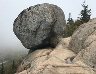
This 1.5-mile round-trip hike quickly leads to North Bubble, South Bubble, and the famous Bubble Rock, with sweeping views of Jordan Pond and surrounding peaks. Starting from the Bubbles Divide parking lot, the trail climbs through forest and steep rocky sections to each summit, then follows blue blazes to Bubble Rock before returning on the same path. It’s a short, rewarding hike with classic Acadia scenery—use caution on exposed granite, especially when wet.


Difficult Hikes
Beech Cliff Ladder
Trail Trailhead: Echo Lake
Distance: 2.4
Type: Loop
Difficulty: Strenuous
Elevation Gain: 488 ft
Time: 1 -2 hours
Dog Friendly: No
Precipice Trail
Trailhead: Precipice Trail
Distance: 2.3 mi
Type: Loop
Difficulty: Hard (climbing)
Elevation Gain: 1,050 ft
Time: 2-3 hours
Dog Friendly: No
Beehive Trail
Trailhead: Beehive Trail
Distance: 1.4 mi roundtrip
Type: Loop
Difficulty: Hard (climbing)
Elevation Gain: 450 ft
Time: 1- 3 hours
Dog Friendly: No
Acadia Mtn Trail
Trail Trailhead: Acadia Mtn
Distance: 5.5 mi
Type: Loop
Difficulty: Hard
Elevation Gain: 1,528 ft
Time: 3-4 hours
Dog Friendly: No
The Beech Cliff Ladder and Canada Cliffs Trail is a short but strenuous featuring four iron ladders, steep rock steps, and outstanding views over Echo Lake, St. Sauveur Mountain, and nearby peaks. Hiked counter-clockwise, you climb the ladders and descend the gentler Canada Cliffs Trail. The route quickly leaves the busy Echo Lake beach area behind and offers dramatic cliff-top vistas—though the ladders and heights may challenge some hikers. Dogs are allowed on leash but must be carried on the ladder section. After finishing the loop, many hikers enjoy a swim in warm Echo Lake.
The Beehive Trail is a short but demanding loop featuring steep granite stairs, exposed cliff edges, and iron rungs that require sure footing and comfort with heights. This iconic Acadia ladder trail climbs about 450 feet and rewards hikers with stunning views of Sand Beach, Thunder Hole, and the Gulf of Maine. Pets are not allowed, and good footwear is essential—especially since wet granite becomes dangerously slippery. Go early to avoid crowds and only attempt this trail if you’re prepared for exposure and challenging terrain.
The Precipice Trail is a very strenuous loop up the sheer cliffs of Champlain Mountain, using iron rungs, ladders, and exposed ledges to climb more than 1,000 feet in under a mile. It is only for fit, sure-footed hikers with no fear of heights and should never be attempted in wet conditions. The route feels more like a non-technical climb than a hike, with boulder scrambles, narrow ledges, and long ladder sections leading to spectacular views over Frenchman Bay. Descending the Precipice is unsafe; hikers return via the North Ridge Trail and the Orange & Black Path. It’s one of Acadia’s most thrilling—but most challenging—adventures.
Acadia Mountain Trail is a short but strenuous hike with a steep climb to a rocky summit overlooking Somes Sound, Norumbega Mountain, and Sargent Drive. Starting from Route 102, the trail ascends quickly over stone steps and ledges, then drops steeply on the far side with some scrambling required. Hikers can return the same way or make a longer 3.7-mile loop with St. Sauveur Mountain or a gentler descent via the Man O’ War Brook Trail. Parking and restrooms are across the road—use caution when crossing.

Photo Credit: National Park Service


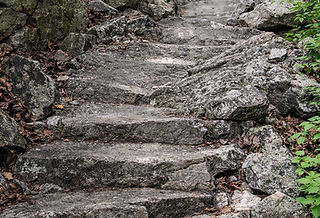
Hike Historic Trails
Sieur de Monts
There are seven memorial paths: Emery Path, Homans Path, Schiff Path, Beachcroft Path, Kurt Diederich's Climb, Jesup Path, and Kane Path.
Emery Path
Distance: .5 miles one way
Terrain: Forested area with steep and rocky sections, granite steps, narrow passages
Homans Path
Distance: .3 miles one way
Terrain: Forested area with steep and rocky sections, granite steps, narrow passages
Schiff Path
Distance: Varies
Terrain: Forested, rocky path, granite steps, steep inclines, exposed ridgeline
Beachcroft Path
Distance: 2 miles round trip
Terrain: Forested path, steep, exposed rocky sections, cut stone steps
Kurt Diederich's Climb
Distance: .4 miles one way
Terrain: Forested area with steep, rocky sections and many granite steps
Jesup Path
Distance: 1.5 miles round trip
Terrain: Compact, flat trail. Wooden boardwalk with benches and pullouts, wide, gravel fire road.
Across the park, there are several other paths constructed during 1924 to 1930: A. Murray Young Path, Gorge Path, Canon Brook Path, Giant Slide Trail, Gorham Mountain Trail, and Cadillac Cliffs Trail. Notable trails constructed by the CCC are Ocean Path and Perpendicular Trail. Today, hikers can follow the footsteps of early settlers, American Indians, and outdoors enthusiasts of another era. Acadia’s historic trails remain just as challenging and rewarding, offering breathtaking scenery and a timeless connection to the landscape that continues to inspire awe.
A scenic, steep hiking trail in Acadia National Park known for its historic, high-quality granite stairwork and impressive views of the Great Meadow and Frenchman Bay. It is a popular route to the summit of Dorr Mountain. As you climb, the trail opens onto broad ledges offering beautiful views of the surrounding forests, meadows, Bar Harbor, and the Porcupine Islands. The path features intricate stonework, narrow passages, and exposed ledges with drop-offs that may be intimidating to those afraid of heights.
A short, steep, moderately challenging memorial hiking trail in Acadia National Park that features intricate granite stonework and steps. It connects to other trails, notably Emery Path and Jesup Path, and can be used to reach the summit of Dorr Mountain. It offers views of the Great Meadow, the Porcupine Islands, and Frenchman Bay. The trail is characterized by impressive, engineered stonework, including granite steps, narrow passages between rock slabs, and a forest environment.
A popular, strenuous hiking trail in Acadia National Park that runs along the east face of Dorr Mountain and connects several other trails, including the Ladder Trail, Emery Path, Homans Path, and Kurt Diederichs Climb, to the mountain's summit. The path is known for its extensive granite steps and exposed ledges offering views of Frenchman Bay and The Tarn. It is part of a series of historic "memorial paths" constructed in the early 20th century.
A scenic and historic 2-mile (round trip) trail in Acadia National Park that leads to the summit of Champlain Mountain, offering panoramic views of Frenchman Bay and the surrounding islands. The trail is generally considered challenging, with sections of granite stairs and rocky scrambles. The trail goes around Huguenot Head and provides excellent views of The Tarn and Dorr Mountain. The summit of Champlain Mountain (1,058 ft) offers sweeping views of the Maine coast, Frenchman Bay, and the outlying islands.
A short, steep, and scenic hiking trail in Acadia National Park, Maine, known for its extensive granite steps and a memorial at the trailhead. It connects several other paths at the base of Dorr Mountain. The trail starts near the Sieur de Monts Nature Center and the Tarn, a marshy pond. Hikers can begin on the Jesup Path briefly before turning onto Kurt Diederichs Climb. The climb is a relentless, steep ascent on granite steps. As you climb, you get views of the Tarn, Huguenot Head, and Champlain Mountain. The path ends at a junction with the Schiff Path and Emery Path, which can be followed to reach the summit of Dorr Mountain.
An easy, family-friendly trail in Acadia National Park, famous for its scenic boardwalk through a white birch forest and marshy wetland. The trailhead is located at the Sieur de Monts Nature Center, which also provides access to the Wild Gardens of Acadia and the Abbe Museum. The trail features picturesque views of the Great Meadow and surrounding mountains like Dorr Mountain, opportunities for birdwatching, and a unique section that winds through a boggy white birch forest.